Summary of flying for Saturday 29 September 2012
| Total Hours | 0h 30m |
| Best Height Gain | 1,400 feet |
| Total Flights | 1 |
| Total Hours | 0h 30m |
| Best Height Gain | 1,400 feet |
| Total Flights | 1 |
Since last weekend I'd watched the weather like a hawk! From Tuesday it looked like Saturday would be a great day for the Dyke but as the weekend approached, the winds backed more to a westerly and the strength was easing. This translates to a small area of lift in front of the pub and the possibility of shared airspace between hang gliders and paragliders; and for those that know the Dyke, not a great mix!
Undeterred by this, I arrived at 10am on Saturday morning. As expected, the wind was smack on WNW and a few paragliders were mixed in with the hang gliders all sharing the airspace. The airmanship was exemplary and with the majority of paragliders sitting it out waiting for it to ease further, I decided it was now or never.
After last weekend's total lack of preparation, I was armed with video camera, GPS, phone and my glider bag. I watched the soaring traffic and concluded it wasn’t particularly buoyant. The thought of a sled ride to the bottom was in my mind but as I launched, I pushed that thought to the back of my mind and focussed on what I could do to stay up!
With minimal lift I scratched back and forth, gaining 20-30 feet then losing it again. After a few beats it was evident the modellers bowl worked best so I focussed most of my efforts at this end of the ridge.
I looked out across to Truleigh Hill and saw a hang glider very low headed to the bottom landing field. Beneath me, another hang glider was setting up for a bottom landing. I was determined not to go down and continued focussing on finding lift.
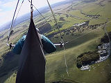
Surrounded by traffic limits choices, but eventually I connected with something away from the hill just out from the modellers bowl. At first I skimmed through the edge of the thermal and began to build a mental picture of where this illusive mass of rising air was. I circled around back into the thermal then pushed toward where I thought the core was. My varios squealed so I tightened my turn and started climbing, slowly getting higher and higher and drifting back over the Dyke.
At 1,400 the lift seemed to dissipate, so with the VG cranked on I ventured up wind as far as I dared. As I looked down I could see more and more paraglider canopies being laid out and very few hang gliders in the air. I assumed the lift cycle had ended and the wind was dropping off; it was time to land, preferably at the top! I assumed I’d get one opportunity to do this before the sky became full of paragliders. That determination focussed me intensively and I landed perfectly in the Paddock.
After last weekend's lack of preparation, I was equipped with everything, including a GPS I had purchased. Earlier, Scott had advised me to simply use the GPS as a recorder by sticking it in a pocket during the flight. This I did and afterwards was able to playback my flight in stunning 3D detail using Google Earth.
Before I could get the data into Google Earth I had to extract it from the GPS and convert to a KML file. After a bit of web searching I found a lovely free piece of software called GpsDump; written by Stein Sorensen. This I successfully used to recover the logs from the Garmin and do the necessary conversions to render into Google Earth.
| Type | Hill Launch |
| Date | Sat, 29 Sep 2012 - 12:00 |
| Glider | AirBorne Sting 3:168 |
| Site | Devil's Dyke |
| Duration | 00h 30m |
| Comments | WNW, backing W and strength increasing. |
| Height Gain | 1,400 ft |
| Distance | 2.15 km |
| Total Hours | 55h 11m |
The total flying statistics up to and including 29 Sep 2012:
| Total Hours | 55h 11m |
| Longest Flight | 1h 20m |
| Gliders Flown | 4 |
| Unique Sites Flown | 20 |
| Best Height Gain | 3,000 feet |
| Total Distance | 28.6 km |
| Furthest Flown | 13.4 km |
| Total Flights | 221 |
| Hill Launches | 103 |
| Winch Launches | 99 |
| Aerotow Launches | 19 |


This page currently has no comments.