Summary of flying for Tuesday 9 March 1999
| Total Hours | 0h 05m |
| Best Height Gain | 0 feet |
| Total Flights | 3 |
| Total Hours | 0h 05m |
| Best Height Gain | 0 feet |
| Total Flights | 3 |
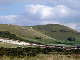
I was coming to the end of my club pilot training and today the wind was right for Mount Caburn. There is no 'official' vehicle access to the top, but John's school has a special arrangement with the farmer and is allowed to drive to the top (but not completely to the top). After carrying the gliders the remaining but short distance to the front of Mount Caburn we began to rig. I was completely blown away by Mount Caburn. It's a rounded hill top so when you walk to the front, all you can see is a panoramic view of the lower land out front. It makes you feel like you are already flying as you stand there looking outward!
John briefed us on the flight path we'd take. The bottom landing was actually out of sight and was around to the left of launch. Our flight plans had been dictated to us; good strong launch, gentle turn to the left until you see the bottom landing, then a gentle turn to the right, back into wind, and set-up for a landing.
Earlier we had inspected the bottom landing field and there were plenty of things to watch out for. Railway line, power cables drainage ditches, trees, fences and hedges! There was a lot going through my mind! I'm not quite sure how it happened, but of all the students there, I was the first off. As I put the flight plan into action I really felt like I was flying somewhere and not doing a simple top to bottom. It was however a one way ticket and it wasn't long before I had turned right back into wind and was lining up for a bottom landing.
It wasn't the best of landings and I was convinced I was going to land in a drainage ditch. Fortunately I remembered the sound advice given earlier which was to watch where you want to go and not look at the thing you want to avoid! With that thought fixated in my mind, I looked at the cattle bridge that crossed the drainage ditch and by some miracle, that's where I landed!
I carried the glider back the short distance to the de-rigging area and watched as the remaining students descended from the top.
After all John's students had successfully launched, John returned to collect us for a second top to bottom. On my second flight, as I turned into wind to line up for a bottom landing, I was aware of a commuter train slowly moving westward along the railway line. As I glanced in their direction, I saw amazed faces looking at me as I slowly descended and matched the speed of the train. I bet they wished they were doing what I was!
Focus quickly returned to the task in hand of landing and my second was far better than my first, landing clear of any significant obstacles.
With daylight dwindling, that was it for the day. Two more top to bottoms from a new site and I was buzzing! John came over to tell me that was it for me now, all I needed was my soaring flights to complete my club pilot rating and that he'd be in touch as soon as the conditions permitted! I didn't know at the time, but I wouldn't have to wait long!
| Type | Hill Launch |
| Date | Tue, 09 Mar 1999 - 11:00 |
| Glider | Aeros Target 16 |
| Site | Beddingham |
| Duration | 00h 01m |
| Comments | Light northerly winds - top to bottom with 90deg turns. |
| Height Gain | 0 ft |
| Distance | |
| Total Hours | 00h 01m |
| Type | Hill Launch |
| Date | Tue, 09 Mar 1999 - 12:00 |
| Glider | Aeros Target 16 |
| Site | Mount Caburn |
| Duration | 00h 02m |
| Comments | Southerly winds, top to bottom |
| Height Gain | 0 ft |
| Distance | |
| Total Hours | 00h 03m |
| Type | Hill Launch |
| Date | Tue, 09 Mar 1999 - 13:00 |
| Glider | Aeros Target 16 |
| Site | Mount Caburn |
| Duration | 00h 02m |
| Comments | Southerly winds, top to bottom |
| Height Gain | 0 ft |
| Distance | |
| Total Hours | 00h 05m |
The total flying statistics up to and including 09 Mar 1999:
| Total Hours | 0h 05m |
| Longest Flight | 0h 02m |
| Gliders Flown | 1 |
| Unique Sites Flown | 2 |
| Best Height Gain | 0 feet |
| Total Distance | 0.0 km |
| Furthest Flown | 0.0 km |
| Total Flights | 3 |
| Hill Launches | 3 |
| Winch Launches | 0 |
| Aerotow Launches | 0 |


This page currently has no comments.